The earth’s wind systems, described in a nutshell.
The most efficient energy form
Heavy fuel oil, marine diesel oil, biofuel, liquefied natural gas, coal, peat, hydrogen, electricity and nuclear: are all energy sources which have to be mined or produced in one or another way. When used, these energy sources are most of the time emitting particles, gasses or can even cause harmful radiation.
Yet, there is an infinite source of energy readily available everywhere above the world’s oceans and plains.
An energy, which, after being consumed, is still there for the next man to use!
An energy which is ABSOLUTELY SAFE, and has no negative side effects with its use. What we are talking about is of course the energy of
wind…
We just have to harness it, which of course comes with a cost. But using wind as a direct source of propulsion on sailing ships, is one of the most efficient ways of using energy. Here you will be introduced to how wind is formed, and where it can be used.
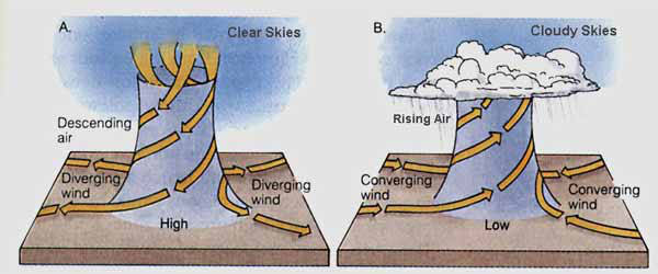
image source : https://laulima.hawaii.edu/access/content/group/2c084cc1-8f08-442b-80e8-ed89faa22c33/book/chapter_4/motion.htm
High and low air pressure
The light of the sun heats the air above: clouds, ocean and landmasses, as of such creating area’s with different air pressure.
Wherever this happens, cold heavy sinking, high-pressure air, wants to move towards: warm light and rising, low-pressure air. This movement of different air masses is what we call wind.
The more difference there is between air pressure, the faster the air movement, and the stronger the wind.
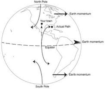
The Coriolis effect
Because of the round shape of the earth, the diameter is exponentially more in the middle, around the equator, than on the ends, the poles. So, because our planet is turning, at the equator the earth is turning faster than in Antarctica or the Arctic.
Because of this when an object moves through the air from the equator towards the North or South, its direction will bend off. This is exactly what happens with the wind as well.
To say, on the Northern hemisphere low-pressure areas move inwards in an anti-clockwise movement. In the Southern hemisphere this rotation is clockwise. Since the high-pressure areas move outwards to the low-pressure areas, here the direction is the other way around.
On a broader perspective, the Coriolis effect also works with the general direction of the trade winds, and other general wind patters.
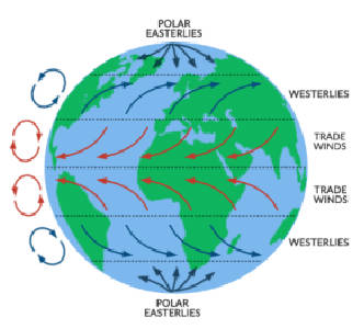
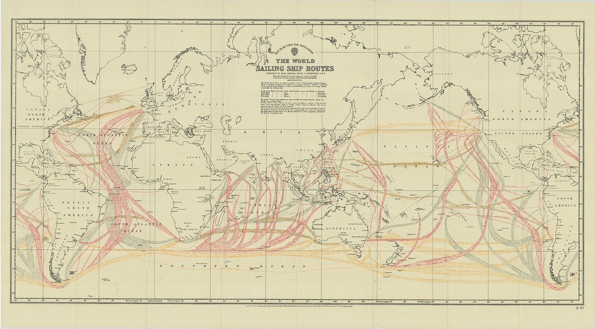
Wind patterns of the world
The prevailing winds, or general circulation of our earth’s air flow is, above and below the equator divided in three different bands or cells.
In between 60- and 90-degrees latitude there are the polar Easterlies. In between 30- and 60-degrees latitudes there are the Westerlies. And in between 0- and 30- degrees are the low-pressure doldrums and Easterly trade winds.
Apart from these three bands, there are other patterns generated because of the continental landmasses. Very locally there are the land and sea breezes. Which find their origin in the differences of temperature between land and sea, during the day and night. Often meaning a Seabreeze, towards the heating land, at daytime. And during the night time, a land breeze, towards the still warm sea. The monsoons are working with the same principal on a more broad scale.
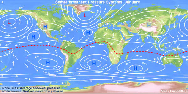
The doldrums
The doldrums, or the Intertropical Convergence Zone (ITCZ), is where the North Easterly and South Easterly Tradewinds converge together. It is a band around the Earth more or less at the latitude of the equator.
Because of its location around the equator the doldrums are an area of warm weather causing the air to rise horizontally, thus creating a low-pressure area. Due to the horizontal direction of the air flow in the doldrums, there appears to be no wind, very light wind or variable wind. This phenomenon is also causing the forming of clouds, frequent thunder and showery weather.
The location of the doldrums follows roughly the change of seasons, moving up or down the equator. This effect is also responsible for the forming of hurricanes or cyclones. Because when the rising warm air of the doldrums, is diverging away from the equator, it will reach the latitude where the Coriolis effect, can start a cyclonic movement of the air.
Tradewinds
The Tradewinds have been traditionally the winds used, by sailing ships, to cross oceans in a very predictable matter. On the Northern hemisphere they blow from a North Easterly direction. In the Southern hemisphere they come from the South East.
These winds exist because the cooler air, with high pressure, flows towards the, warmer air with lower pressure on the equator. The Coriolis effect gives them their Easterly direction.
Like with the doldrums, also the Tradewinds are affected by the change off seasons. In summer time when there is less difference of temperature between air masses, they are less powerful, whereas in wintertime with greater air pressure difference, they can become very strong.
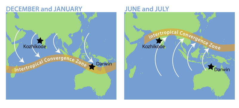
The Monsoon
The Asian monsoon is a huge wind system affecting the Indian ocean and Southern Asia. The monsoon is strongly linked to the seasonal changes of temperature. Its winds shift annually from South West, in the warmer months of July through September, to North East in the cooler months.
The monsoon is basically another Sea- and land-breeze system, but instead of being propelled by the temperature changes from day and night, it is created with the changing temperature of summer and winter.
With warm South Westerly winds, also come the very wet and unstable weather patterns, known as the rain season. Although due to geographical features like the Himalaya mountains, the monsoons in the Indian ocean and South of Asia are the strongest, there are many different monsoons on our planet, pushing different weather effects.
Images: UCAR
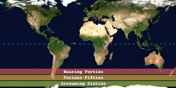
Roaring forties, furious fifties and screaming sixties
In the Southern Ocean is a band of sea which stretches unbroken around our globe. This is where predominantly the Westerly winds blow. During the great age of sail this route was used by every deep-sea ship sailing around the world. Taking this route, of the roaring forties, was called: “running the Easting down”.
And the more South you go, the stronger the winds. That’s why after the latitudes of the forties, the lower more Southerly latitudes are called the furious fifties and screaming sixties. With the added challenge of the sea being littered or totally obstructed by icebergs, the closer one comes to the Antarctic continent.
The same systems are at work in the Northern latitudes of the Atlantic and Pacific Ocean. However here the full band of sea is broken by the landmasses of North America, Europe and Asia, and as such the wind and waves have less distance to built their ferocity.
The polar Easterlies
Less interesting for the seaman, because these areas are not on regular sea routes. Although, because of climate change, unfortunately the Northern passage is more and more ice-free and open for navigation.
These winds are usually light and blowing from the East. They develop under the influence of the cold and dry high-pressure areas on the poles, combined to the power of a maximum Coriolis effect.
Conclusion
This is just the top of an iceberg of meteorological knowledge gathered by seamen like Captain Maury, the captains of the Laeizs shipping company and many other master mariners.
All this information was known more than a century ago, and used to ship thousands of ship cargoes, month after month, year after year. Until the black smoke of steam and diesel took over.
Nowadays, with computer simulations, satellite views and an unlimited amount of weather data, we know even more about this great source of free energy.
Now walk outside on a windy day.
Feel the pressure and power of the wind.
Feel its energy.
A form of energy, of power, more obvious than any of the currently known fuels.
It holds the advantage, that it is not flammable nor will be likely to explode.
And it is there for everybody, to be used as much as you want.
So, let’s make use of it!
Thanks for signing on,
Following seas and royals all the way!
Captain Jorne Langelaan